Last week I talked about how Oregon and Washington were covered in several massive floods of lava that hardened into the cliffs and layers of basalt we see today. Another topic that I often touch on in my Ecoregions of Oregon class (hence the title of this post) are the Missoula floods. By this point in the class I’ve already touched on the exotic terranes that make up some of the oldest rocks in this part of the Northwest (a topic I’ll talk more about later) and the aforementioned basalt floods. This sets the stage for the next massive event that shaped the landscape, and we fast-forward to the last ice age, approximately 19,000 years ago.
From Fire to Ice
Ice ages are global cooling events in which the ice that we think of as a primarily polar phenomenon advances further south (or, in the case of the Antarctic, north.) Not only does this lower the levels of the oceans dramatically, causing previously inundated land to be exposed, but large portions of territory are covered in sheets of ice that can be several thousand feet thick. Of particular interest here is the Cordilleran ice sheet, which covered sections of modern-day Alaska, British Columbia, and northern Montana and Washington.
At this time, the ice sheet had advanced far enough into Montana and Idaho to dam the Clark Fork River, which had been a major avenue for glacial meltwater to flow from the western slopes of the Rockies in that region to the Pacific Ocean. The backed-up water created Glacial Lake Missoula. Further west, the Columbia River–the largest river in the Pacific Northwest–was blocked off, and Glacial Lake Columbia formed. Sometimes the ice would create a division in Columbia, and the eastern section became Glacial Lake Spokane.

Of the three, Glacial Lake Missoula was certainly the biggest, equal in size to today’s Lakes Ontario and Erie combined. And the only thing holding five hundred cubic miles of water back was the ice dam. Every so often this dam failed; there is still debate as to exactly what happened. It could have been that the volume was enough to “float” the 2000-foot-high dam like a mass of ice in a glass of water suddenly shifting upward, or the water may have built up enough to simply spill over the dam entirely. There’s evidence pointing to anywhere from forty to a hundred floods from 19,000 years ago to 13,000 years ago, and it’s likely that similar floods occurred here earlier in the Pleistocene, as early as 2.5 million years ago.
However it happened, each time the dam failed this massive amount of water was suddenly released, and it didn’t take its sweet time leaving, either. Glacial Lake Missoula likely emptied within a matter of a few days–not weeks, not months, DAYS– creating a flood that traveled up to eighty miles an hour. And all that water had to go somewhere, fast.
The Flood’s Own Oregon Trail
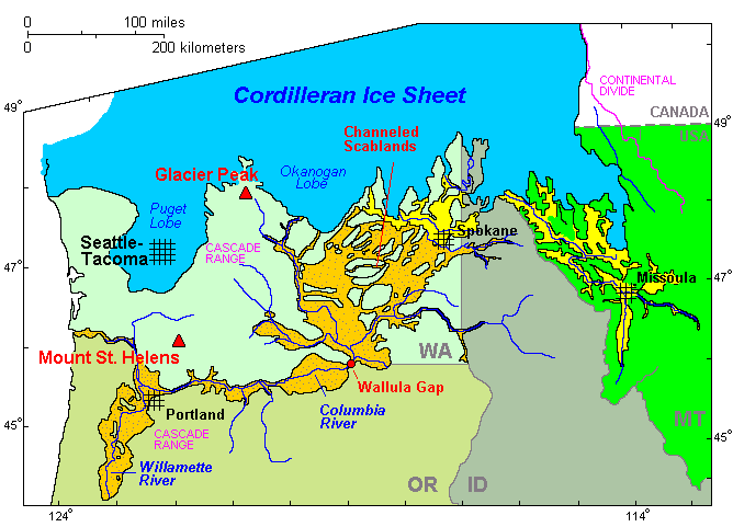
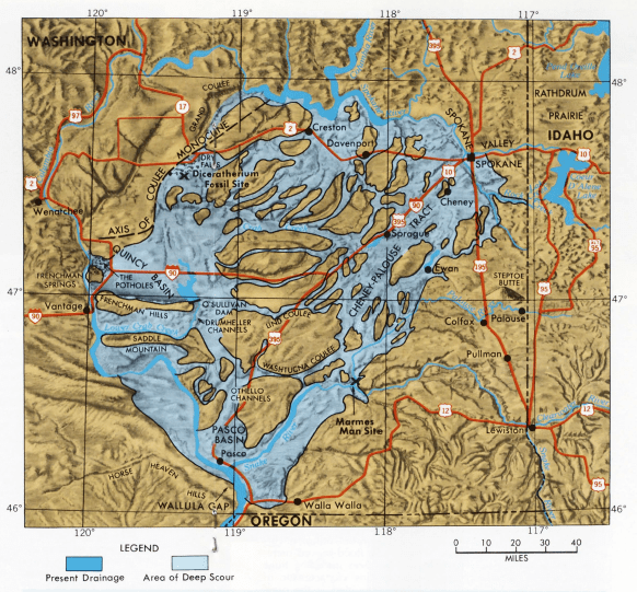
When Glacial Lake Missoula (east yellow section in map) emptied, crashed into Glacial Lake Columbia (west yellow section), and cascaded over places like Dry Falls, all that floodwater didn’t stick to one neat pathway. This USGS map demonstrates that many large sections of eastern Washington were scoured by floodwaters, though each flood may have taken a different route than the last. When a flood did make far enough down the Columbia River, the water was squeezed through the Wallula Gap. This narrow point was only a little over a mile wide, forcing the water through at high speed, and creating a flood crest hundreds of feet high that rushed down the Columbia.
The floods were so powerful that they carried debris all the way to the Pacific Ocean, and these deposits can be found on the ocean floor hundreds of miles west of the mouth of the Columbia. But not all the water made a straight shot to the coast. Tributaries along the Columbia often found themselves the recipients of massive amounts of floodwater.
Perhaps the most impressive result was the Willamette Valley. The Willamette River empties into the Columbia in present-day Portland, OR. But it originates in mountains east of Eugene, with three main forks joining just north of the city. Topographic maps clearly show the wide, flat river valley.
What they don’t show you, and which is best seen in person when possible, is the incredibly rich soil created from the massive amounts of silt and other deposits left by the floods each time they diverted south along the Willamette. Instead of washing into the ocean, it settled in the valley as the waters receded. Not only is the resulting soil excellent for growing plants of all sorts, but it’s thick–some places have deposits 300 feet deep. And the deposits can be found all the way to Eugene, over a hundred miles south from where the Willamette meets the Columbia.
More Missoula Floods Aftermath
Not all places were as lucky. After all, all that soil had to come from somewhere, and that somewhere was eastern Washington. Millions of acres of land were stripped bare of everything but the underlying basalt through numerous floods. Known today as the Channeled Scablands, this area has barely had time to recover from a geological perspective. While some quiet side valleys in the area may have enjoyed a similar buildup of soil as the Willamette, the higher elevations directly in the path of the water were left as bare rock, further eroded by each flood’s passing. While life has returned to the Scablands, it is still deeply–and literally–marked by its recent geological past.
The water didn’t just strip away soil, though. It was so powerful that it carved into the basalt. Potholes were created when the water would form into spiraling eddies. Sand and other debris enhanced the erosive properties of the water.
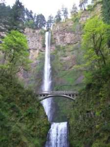 As the Missoula Floods violently eroded the basalt left over from the earlier lava floods, they often created deeper and wider channels for the rivers that carried it. The Columbia River Gorge is the most famous example thereof. While this river has always been a major drainage in the Pacific Northwest, the flooding created its immense depth today. The effects are especially dramatic on the south bank of the river west of the Cascades; some of the many waterfalls that can be seen along this stretch of Interstate 84 are rivers and streams whose deltas were worn away by the floods. Instead of flowing gradually downhill into the Columbia, they instead leap off sharp precipices hundreds of feet high, only to flow rather sedately for the last leg to their destinations.
The floods left other evidence behind. They were so powerful they could move enormous boulders with ease. The rocks, a type of glacial erratic, sometimes ended up hundreds of miles from their origins. (Rocks moved by solid glacier ice are also known as erratics, for what it’s worth.) As the floodwaters slowed down, they began dropping their heaviest loads first, then smaller rocks, and finally sand and silt. Scientists have even been able to use the presence or lack of certain sizes of debris to estimate the speed at which the water was traveling at a given place; the heavier the rocks being dropped, the faster the water was going.
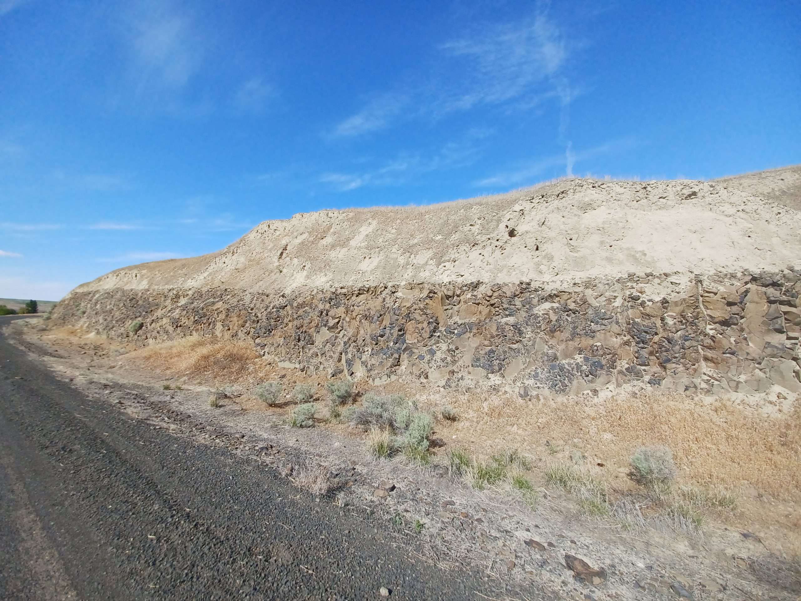
One of the downsides of having multiple floods, at least from a historical perspective, is that a flood could alter or even erase some of these records of previous floods. An erratic deposited in one location could be pushed further downriver if a larger, stronger flood came along, for example. On the bright side, there are places where each subsequent flood would add another layer of silt on top of that left by its predecessors. While some have eroded a bit with time, others still display very cleanly delineated layers, allowing a person to count floods like one might count tree rings.
Both sets of floods–those of basalt, and those of glacial water–are a big part of what makes the Pacific Northwest such an absolutely fascinating place geologically speaking. There’s plenty more for future articles; in the meantime, if you have a particular topic you’d like to see me write on, drop me a line!

Interested in knowing what kinds of plants were imported that were not in the Willamette Valley before the floods. Presumably lots of seeds came down with the flood silts and sands. Can we tell how the plant ecosystem looked before and how it changed?
I would imagine botanists have taken samples of seeds and pollen from various soil layers. However, given that conditions are quite different on each side of the Cascades, it’s likely that any seeds that came from the floods wouldn’t survive too well, even if the Willamette Valley is drier than the mountains on either side.